Dynamic Labeling - Active Range Optimization Problems - Experimental Results, by R. G. Cano, C. C. de Souza and P. J. de Rezende
Citing this page:
-
Use the BibTeX entry:
@Misc{csr2017,
author = {Rafael G. Cano and Cid C. de Souza and Pedro J. de Rezende},
title = {Dynamic Labeling -- Experimental Results},
year = {2017},
note = {{\sl www.ic.unicamp.br/$\sim$cid/Problem-instances/Dynamic-Labeling}}
}
Problem description
We study labeling problems for point features on interactive maps. Such maps allow users to execute operations to alter the state of the visualization. Two of the most common operations are rotation and scaling. For readability purposes, as one of these operations is executed, labels must maintain their size, shape and orientation on the screen. This may cause labels that were previously disjoint to overlap (see Fig. 1). We handle overlaps by omitting one or more labels from the visualization during specific intervals of angles or scales.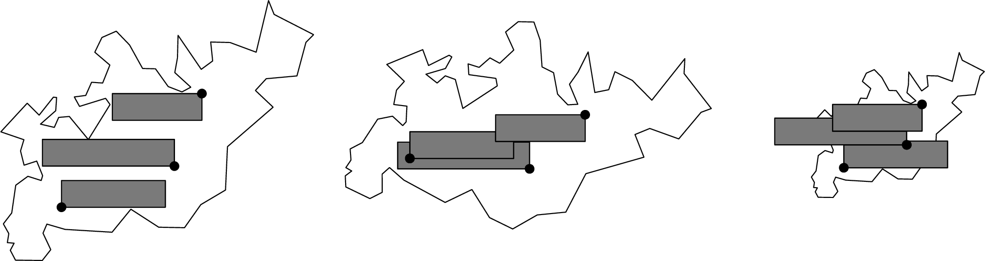
Figure 1: Original map (left), result after a clockwise rotation (middle) and after zooming out (right).
Input Instances
We used two sets of maps constructed from real-world data and made available by Gemsa et al. [1]. The first set was built from data on the most populous cities in six countries (France, Germany, United Kingdom, Italy, Japan and USA) using cartographic scales of 65pixel = 20km, 50km and 100km. The second set is based on data from restaurants in four cities (Berlin, London, New York and Paris) and uses cartographic scales of 65pixel = 20m, 50m, and 100m. Each input file specifies the position and size of all labels, and their position relative to their associated anchors. The original instances can be downloaded at the authors' website:http://i11www.iti.kit.edu/projects/dynamiclabeling/. To experiment with the weighted variant of the problem, we gathered data on the population of all cities in the first set of maps. We used these values as weights to prioritize the most populous cities. It was necessary to modify some of the input files because the original ones contained cities with duplicate names (this might happen, e.g., if two cities belong to different counties or states). No changes were made to the set of labels or to their sizes and locations. We simply changed the text of each label so that they become unique. Our modified input files can be downloaded here:
City instances (with weights) (94.5 K).
Experimental Results
We ran our experiments on an Intel Xeon CPU X3470, 2.93 GHz, with 8 GB RAM. Integer programs were solved with CPLEX 12.5.1 using traditional search with a single thread. The code was written in C++ and compiled with gcc 5.4.0. We considered both the unweighted and the weighted variants of the problem. We tested an integer programming formulation from [1] with the soft and the hard conflict models, using 1R, 2R and 3R (recall that model KR allows at most K active ranges per label). We experimented with two operations: rotation and scaling. Our complete set of results that were reported in [2, 3] can be downloaded here:Results (ODS format) (131.7 K),
Results (CSV format) (25.6 K).
Acknowledgments
This work was supported by Fundação de Amparo à Pesquisa do Estado de São Paulo (FAPESP), grant 2012/00673-2, and Conselho Nacional de Desenvolvimento Científico e Tecnológico (CNPq), grants #155498/2016-9, #311140/2014-9 and #304727/2014-8.References
- [1] Evaluation of Labeling Strategies for Rotating Maps, A. Gemsa, M. Nöllenburg, I. Rutter, ACM Journal of Experimental Algorithmics 21 (1) (2016) 1.4:1–1.4:21.
- [2] Fast Optimal Labelings for Rotating Maps, R. G. Cano, C. C. de Souza, P. J. de Rezende, In: WALCOM: Algorithms and Computation (WALCOM 2017), vol. 10167 of LNCS, Springer, 161–173, 2017.
- [3] Solving Dynamic Labeling Problems to Optimality Using Solution Space Reductions, R. G. Cano, C. C. de Souza, P. J. de Rezende, submitted (2017).
Address
Rafael G. Cano, Cid C. de Souza and Pedro J. de RezendeUniversidade Estadual de Campinas
Instituto de Computação
Av. Albert Einstein, 1251
13083-852, Campinas, SP, Brazil
Phone: +55 19 3521.5877
Fax: +55 19 3521.5847
e-mail: